
Latest News
Back to Articles

.jpg)
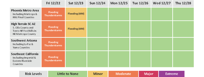
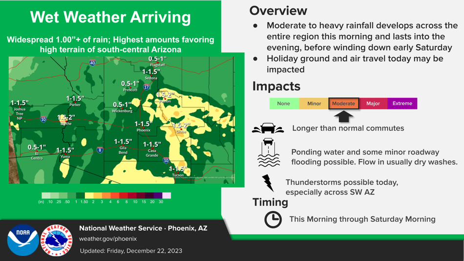
Minor to moderate flood impacts possible today. Rain with accumulations averaging around 1.00" today across SE CA and SW AZ and 1.00-1.50" across SC AZ. Highest totals of 1.5-2.0" likely across higher terrain north and east of Phoenix.
Greatest chances for thunderstorms are expected across SW AZ and Lower Colorado River Valley area today. A few strong thunderstorms are possible with strong winds, hail, and locally enhanced rainfall/flooding the main concerns.
Scattered showers on Saturday mainly from Phoenix and areas to the north and east of Phoenix.
Near to slightly below normal temperatures through the first half of next week.
CHANGES FROM PREVIOUS BRIEFING
- Flood Watch has been extended until midnight tonight PST/1 AM MST for SE CA and the Yuma area.
- Increased threat for a few strong storms capable of producing some strong winds and hail across SW AZ and Lower Colorado River Valley today.
WEATHER RISK OUTLOOK
Risk levels incorporate potential impacts from weather hazards and likelihood of occurrence. The weather hazard with the greatest risk wilbe listed first in the matrix.
DETAILS_Page_2.png)
_Page_3.png)
FOR MORE INFORMATION
For the latest forecast updates, visit weather.gov/phoenix.
.png)
.png)
.png)
.jpg)